

The Ancient Period (up to 400 A.D.)
The Mediaeval Period (400 to 1500 A.D.)
The Early Modern Period (1500 to 1900 A.D.)
The Recent Period (1900 A.D. to the present)
However, it's important to note that these stages are not entirely separate from each other. Throughout history, there have been periods of regression and stagnation, punctuated by moments of rapid advancement. During these periods of advancement, outdated ideas often coexisted with new ones. Additionally, the application of theoretical knowledge did not always closely follow its development, resulting in processes that cut across these stages.
Ancient Period:
Ancient Period, which can be subdivided into the following components:
Primitive Cartography: Early civilizations demonstrated an impressive ability to create rudimentary maps of their familiar territories. These maps were often drawn on materials like wood, bone, or terracotta, and they depicted relative positions and distances of localities known to these

Babylonian Map

Oldest survival map , 2500 BC
Greek Cartography: The ancient Greeks possessed knowledge about various geographical areas. They created itinerary maps that displayed stages along routes leading to trading areas and important centres, such as Mediterranean coastlines and the capital of Persia. Pioneers like Hecataeus, Anaximander, and Herodotus designed maps of the regions they were familiar with.

Hecataeus Map, 500 BC

World map of Eratosthenes

Hipparchus Map, 150 BC

World map of Herodotus, 440 BC
Eratosthenes, a notable figure from ancient Greece, played a significant role during this period. He accurately calculated the Earth's circumference and attempted to address the challenge of representing the spherical Earth on a flat surface by extending parallels eastward. His contributions, along with those of Hipparchus, laid the groundwork for the development of scientific cartography.


Roman Cartography: Romans, too, engaged in cartographic efforts. They produced maps that reflected the territories they controlled. This period saw the utilisation of geometric methods for land measurement, and these measurements were depicted on plans. Maps for military and administrative purposes were developed during this time.

Asian Cartography: Cartographic endeavours were not limited to the West. Asian civilizations like the Babylonians and Chinese also created maps. The ancient Chinese, for example, generated maps that showcased their understanding of the world around them.

Mediaeval Period:
During the early mediaeval period, geographic knowledge in Europe was at a standstill and cartography became copy work there. Most of the maps of this period or so called T-O maps centred around Jerusalem and the Christians created four-cornered map.
Thus, it is clear and beyond doubt that Ptolemy’s Geography exerted almost no influence on the early mediaeval period in Europe. However, European cartographic knowledge influenced Arab cultures and Arabian explorers tried to produce some world maps in that time. Al Masudi, Al Idrisi compiled world maps in their time. More detailed knowledge of the Arabian Sea and Bay of Bengal and parts of the Indian Ocean become vividly available.


By the end of the 13th century, the use of mariner’s compass and the construction of navigation charts helped sailors to collect more information about the boundaries of the coastline. Italians were the leading cartographers in this period. Catalan world Atlas was prepared in 1375 AD.

Modern Period
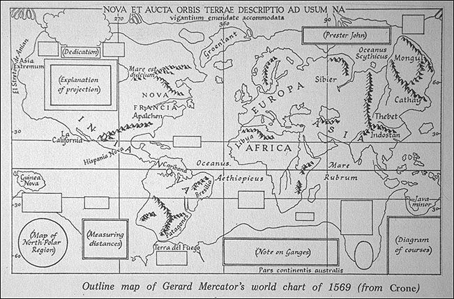
Modern period started with the age of enlightenment in Europe and the first world map was published by G Mercator using projection in 1569. After Mercator many renowned cartographers produced world maps and suitable projections.
Development of land surveys helps to march in preparing modern maps with more details.
Age of Modern Cartography: Remote Sensing and GIS
During the 20th century, the introduction of the aeroplane, followed by advancements in satellite-based remote sensing technology, brought a fresh dimension to cartography and expanded its horizons through the practice of remote sensing. This innovation offered an aerial perspective of the Earth, which proved both time-efficient and cost-effective compared to traditional ground surveys.
In its most comprehensive interpretation, remote sensing involves the collection or retrieval of data related to an object or occurrence using a recording apparatus that doesn't necessitate direct physical contact. This method operates from a distance, often utilising tools like aircraft, spacecraft, satellites, or ships to accumulate information about the surrounding environment. The approach encompasses a variety of instruments, including cameras, lasers, radars, sonars, seismographs, and gravimeters. While contemporary remote sensing techniques often involve digital processes, non-digital methods are also applicable.
With the development of satellite technology between 1970 and 1980, remote sensing through satellites received more attention from researchers, cartographers and genera users. An image taken from space using a spacecraft as the platform and scanners or specially designed camer as sensors to detect the given area of the earth's surface is termed satellite imagery. The remote sensor system makes use of the emitted or reflected electromagnetic radiation of the examined object and measures a larger area of the earth. Satellite imagery can be widely applied and is extensively used by scientists, researchers, and planners in map-making, urban and regional planning, agriculture, forestry, ecology and environment, soil survey, natural resource mapping, oil and mineral exploration, and so on.
In traditional cartography, the map represented both the database and the display of geographic information whereas in GIS (Geographical Information Systems), the database, analysis, and display are physically and conceptually separate aspects. Geographic information systems include several elements such as computer hardware, software, digital data, people, and institutions for collecting, storing, retrieving, analysing, and displaying georeferenced data or information about the Earth. Modern map-making relies much more on GIS, which provides flexible computer-aided databases and maps.
Introduction and integration of GIS with Cartography brought digital revolution in map making and initiated new form of Cartography- the Digital Cartography.
No comments:
Post a Comment